Borusan Contemporary,
is a contemporary art, collection and education initiative of the Borusan Kocabıyık Foundation.
Personal Data Protection
Cookie Policy
© Borusan Contemporary, 2026.
Blog
A Conversation with Başak Sönmez Beyazyürek and the TEMA Foundation
12 June 2026 Fri
Experts
Dr. Hikmet Öztürk (H.Ö), TEMA Foundation Advisor
Dr. Ferhat Taze (F.T), Head of Forestry and Rural Development Department, TEMA Foundation
- First of all, we would like to thank you for joining this conversation on the theme of Erosion, which we are conducting in connection with the exhibition titled Shifting Topography by Edward Burtynsky, currently on view at Borusan Contemporary. Canadian artist Edward Burtynsky conceived the Erosion project in spring 2022 at the invitation of Borusan Contemporary Art Collection, in collaboration with the TEMA Foundation. This project has also become the central theme of this year’s exhibition. As is well known, the TEMA Foundation—an organization you have supported for many years with your expertise and dedication—was established in Türkiye in 1992 with the mission of combating erosion and protecting natural assets, and today it has evolved into a grassroots movement with more than 1.25 million volunteers. How did it feel to see, through Burtynsky’s lens, photographs of landscapes that you have worked for years to restore and rehabilitate?
- H.Ö: First of all, I would like to thank you for bringing the exhibition Shifting Topography to audiences through the lens of Edward Burtynsky. Since its very existence, the Earth has been going through a continuous transformation, which is shaped jointly by natural processes and human impact. In my view, witnessing these two dynamics side by side in the exhibition is both profoundly informative and deeply moving. While the landscapes shaped by the erosive power of water and the aesthetic beauty captured in the photographs deepened my admiration, the sense of optimism I felt from the efforts to heal the wounds inflicted on lands left bare by human hands truly warmed my heart. As the TEMA Foundation, we have for years drawn attention to how erosion—accelerated by human activity—threatens both soil and life itself. We emphasize that losing soil means losing life, and that protecting soil means safeguarding not only humanity but all forms of life. The greatest source of happiness in these efforts is witnessing how life flourishes once again in nature as a result of restoration activities. As I moved through the exhibition, it felt like walking along terraces and touching growing saplings. I felt profoundly grateful to everyone who contributed throughout this process.
- F.T: I would also like to thank you for this conversation. The most significant factor accelerating erosion is the destruction of vegetation cover, which exposes topsoil to rainfall and erosion. Practices such as depriving the soil of vegetation, improper land use, excessive tillage, plowing along the slope, and converting natural areas unfit for agriculture into farmland lead to serious soil losses, particularly in agricultural lands. Today, Türkiye loses approximately 642 million tons of soil to erosion each year—meaning that one centimeter of topsoil, which takes 500 years to form, can disappear in as little as 16 years. The landscapes I observed through Burtynsky’s lens evoked strong and conflicting emotions in me. On the one hand, witnessing large-scale environmental destruction induced by human activity, and seeing how soil becomes vulnerable with the loss of vegetation, aroused a deep sense of sorrow. On the other hand, it was hope-inspiring to see the terraces built to combat erosion, the soil retained, and the plants that were regrowing in these areas. These photographs urge humanity to confront the damage it has inflicted on nature, while also making visible the value of efforts to protect the soil. As a person working in a civil society organization whose fundamental purpose is to protect natural assets—foremost among them soil—and to combat erosion, I think it is invaluable that erosion is addressed through artistic lenses. I believe this approach both raises awareness and strengthens engagement in the fight against erosion.
- The photographs Burtynsky captured in Nallıhan and Beypazarı districts of Ankara focus on geographies where erosion can be observed in its most intense form. We are confronted with landscapes that seem almost otherworldly, formed over millions of years by the shaping of sedimentary rocks through wind, rain, and gravity. As experts, could you elaborate on the differences between natural geological erosion processes that create these formations and human-induced erosion that threatens agricultural sustainability and ecosystem integrity?
- H.Ö: One should consider erosion under two main categories: natural erosion and erosion accelerated by human activity. Natural erosion occurs as a result of the interaction between soil and the parent rock that forms it, with the influence of water, wind, and gravity over millions of years. While some rocks are highly resistant to water, others are much more sensitive; water dissolves, loosens, and carries them away. The photographs Burtynsky took in Nallıhan and Beypazarı districts reveal such “footprints” of water in a crystal-clear way. As the saying goes, “water finds its way,” and we observe that erosion increases in areas where water flows and eventually turns into stream beds; conversely, soil resistance increases in areas with vegetation. As long as these cycles are natural, they do not pose a threat; on the contrary, they are the very source of ecological diversity and life. Indeed, a large portion of today’s fertile agricultural plains was formed as a result of such natural processes. The real concern, as we at the TEMA Foundation have long emphasized, is human-induced—accelerated—erosion. When the vegetation cover that protects the soil is worn away, the soil becomes directly exposed to the effects of raindrops, which results in the gradual loss of topsoil—the most fertile layer—often in ways that are not immediately visible to the naked eye. Every piece of soil lost is, in fact, a piece taken from our future.
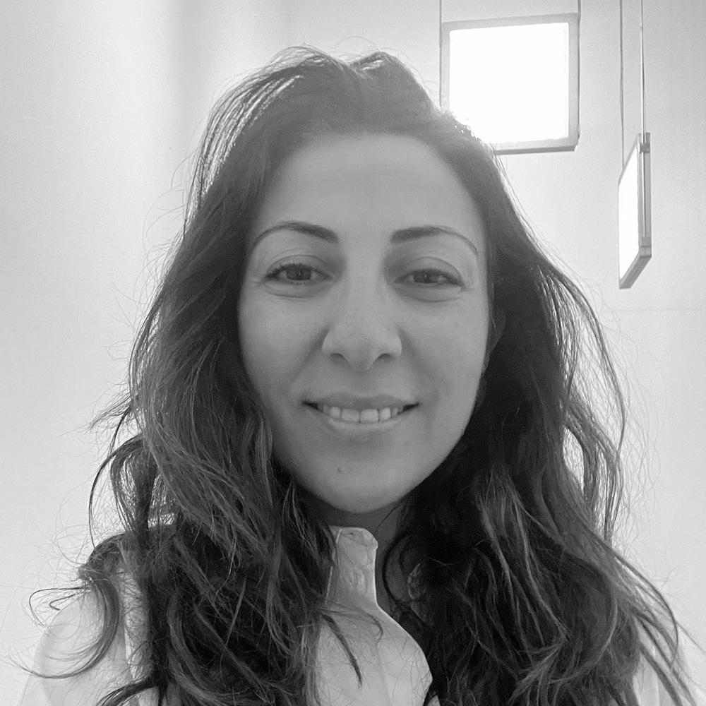
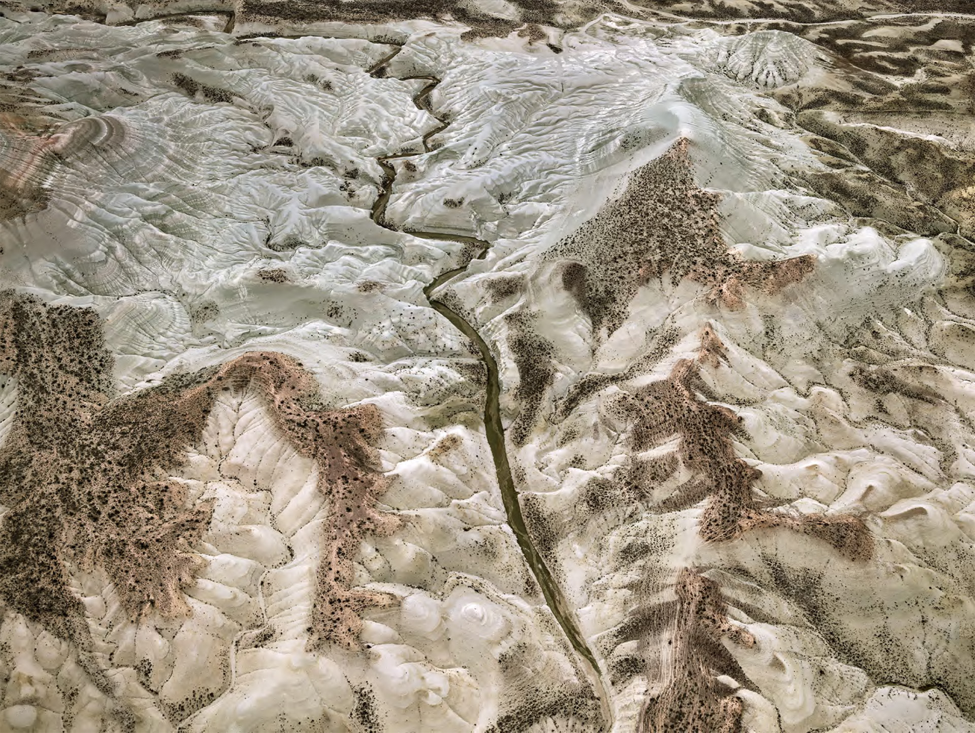
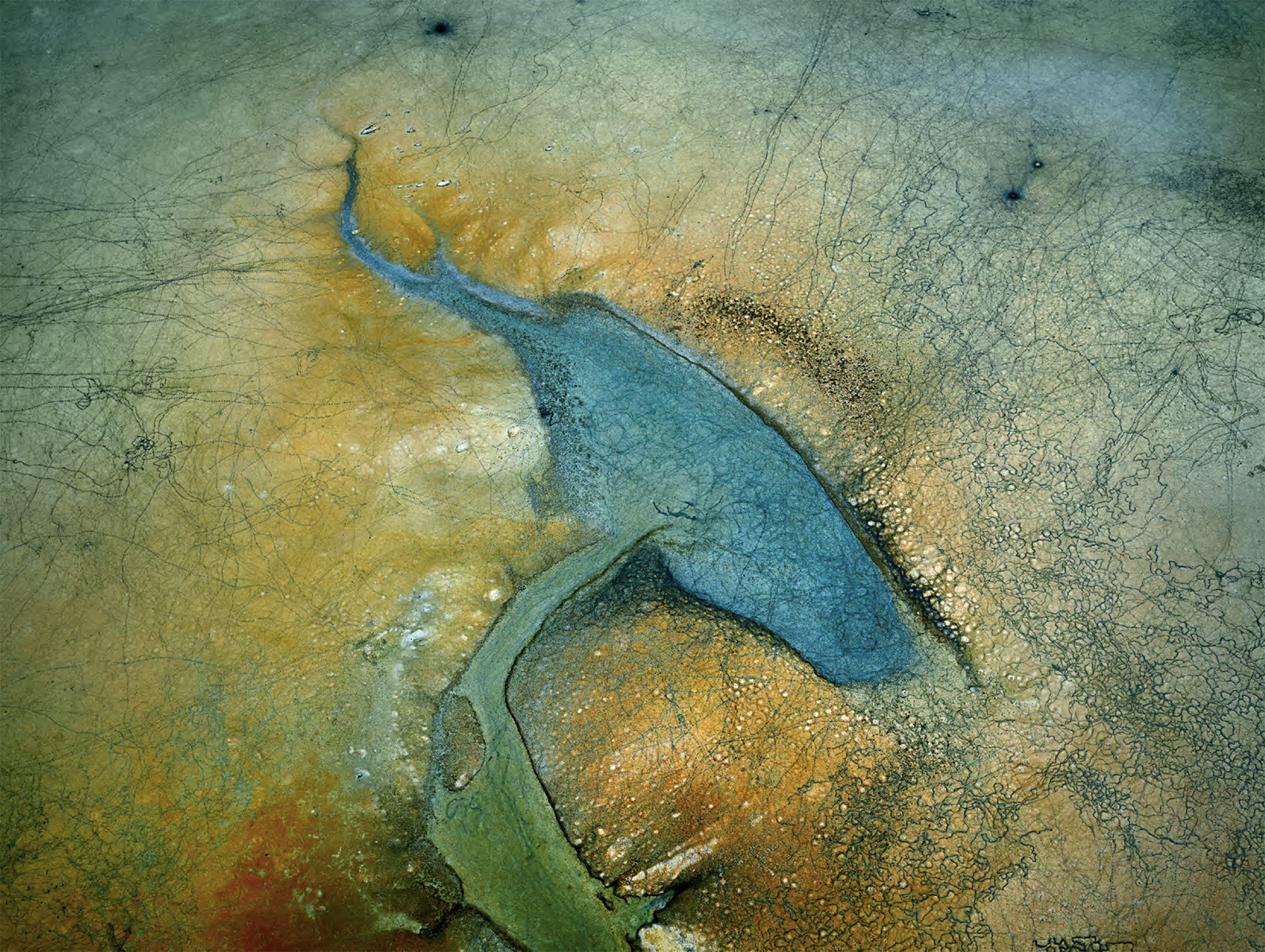
- F.T: Natural (geological) erosion occurs within nature's own dynamics and is offset through soil formation. However, what we predominantly observe in the photographs of Burtynsky is accelerated erosion resulting from human activity. With the destruction of vegetation cover, landscapes are left bare; particularly in sloped areas, topsoil is rapidly transported by wind, rainfall, and surface runoff. This can be seen very clearly in the photograph taken in Beypazarı (Image 1). The vegetation-deprived, white-colored areas represent infertile areas that have lost their topsoil. In contrast, the brownish tones visible on ridges and certain slopes indicate areas where vegetation is still able to protect the soil, though to a limited extent. The darker coloration seen in the riverbed along the valley floor represents the fertile topsoil that has been transported from higher elevations through erosion. A similar situation can be observed in the Nallıhan example (Image 2), where red-brown topsoil has again accumulated in riverbeds, revealing the effects of erosion. As seen in the images from Beypazarı, the area is dominated by poor and infertile subsoil that has lost its topsoil over time and is whitish. This visual narrative presents, in a striking manner, the destructive impact of human-induced erosion on agricultural sustainability and ecosystems.
- In the exhibition, erosion control projects in Burdur, Kayseri, and Karaman provinces come to the fore. When viewed through the artist’s lens, these landscapes appear as rhythmic, almost abstract compositions shaped by human intervention. As seen in these examples, could you tell us the decision-making process behind large-scale land-shaping projects? In different geological and climatic contexts, how do you decide which erosion control techniques are applied? Despite the rapidly advancing ecological crisis, can you share long-term success stories attributed to such interventions?
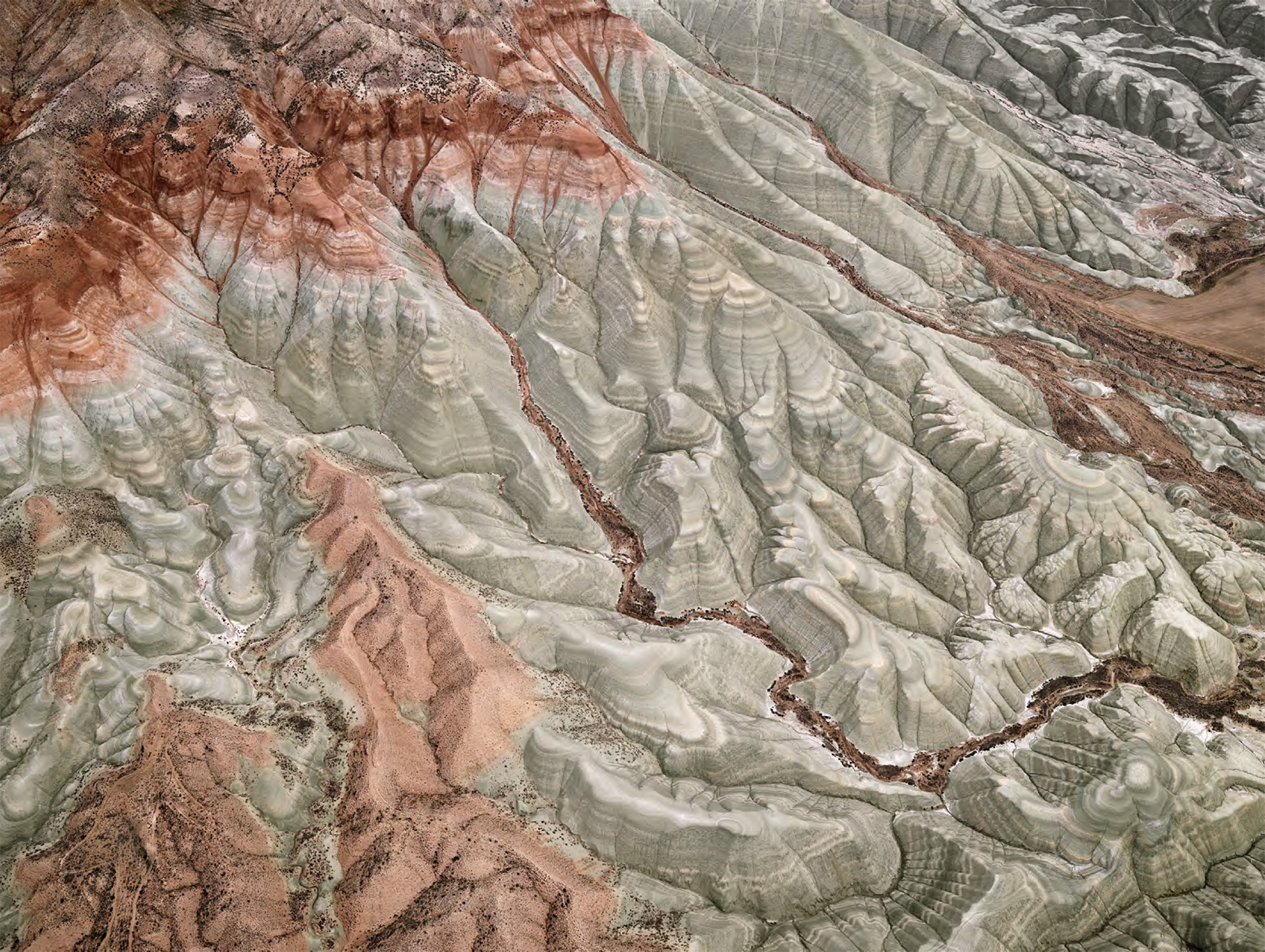
- H.Ö: Erosion is the most widespread cause of land degradation worldwide. In Türkiye, it occurs across all climate types and geographies. However, it does not occur with the same intensity everywhere. Climate, parent rock and soil type, land slope, and vegetation cover are the key factors determining both the extent and impact of erosion. When faced with such a widespread problem, the question of “where to begin” becomes critical. Erosion is often not directly visible to the naked eye; however, it becomes apparent through indicators such as changes in the color of rivers during floods, the accumulation of mud in agricultural lands, or the occurrence of dust storms. For this reason, erosion control and soil conservation efforts have historically been initiated first in basins suffering from loss of life and property, and where agricultural production and human health have been affected significantly. Tokat Behzat Stream, the Pozantı Çakıt Basin, Burdur, and Karapınar can be listed among the examples of such areas. Over time, these efforts are followed by the protection of dam basins used for energy production and the extension of dam lifespans. Erosion control is underpinned by two basic principles: first, reducing the erosive and transport capacity of water or wind; second, bringing the soil together with its protector—vegetation—by taking into account the climate and soil characteristics of the area in question. One of the most effective methods against water erosion is terracing. Through terracing, the flow velocity of water is reduced, thereby diminishing its erosive force. In arid areas, terraces are designed to increase infiltration and water absorption into the soil; in areas with high or intense rainfall, they are constructed to safely direct excess water through controlled flow paths. The width and spacing of terraces are determined according to the slope of the land. For wind erosion, the most effective measures are windbreak strips. The areas photographed by Burtynsky in Burdur, Kayseri, and Karaman provinces are characterized by steep slopes and semi-arid climatic conditions. Therefore, terraces in these areas are designed parallel to contour lines in a way that enhances water absorption. The saplings planted alongside these structures anchor the soil with their roots. Over time, these areas transform into forest ecosystems. Thus, they not only prevent erosion but also transform into landscapes storing carbon, regulating climate, and enhancing biodiversity. The most powerful message I see in Burtynsky’s photographs is this: The damage we inflict on nature can also be healed by human hands.
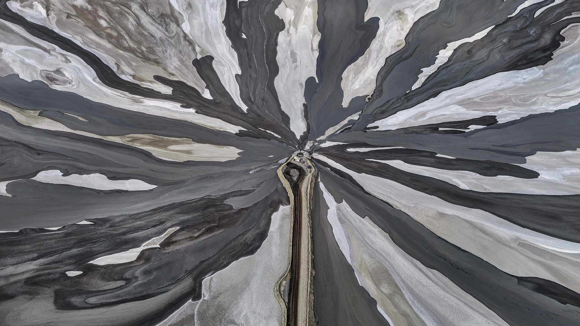
- F.T: Burtynsky’s aerial photographs of erosion control sites in Burdur, Kayseri, and Karaman provinces initially reminded me of contour maps showing elevation lines because terraces constructed on sloping terrain, when built perpendicular to the slope, create precisely such a visual pattern. Foresters often describe these efforts with the phrase “to tend the soil with the delicacy of embroidery.” Burtynsky’s photographs bring this expression vividly to life. Thanks to advances in technology, terraces extending for kilometers can now be built with great precision utilizing excavators. In these areas, it is clearly visible that every piece of land lacking vegetation and possessing suitable soil depth has been carefully terraced. In the past, however, such work was carried out entirely through human labor. As seen in Burtynsky’s photograph taken in Burdur, terraces were carved into slopes so steep that even standing upright was difficult, and saplings were planted along these terraces (Image 3). Although terraces built by manual labor were narrower and could only be applied to more limited areas compared to mechanized methods, they vividly showcase the efforts exerted and the challenges overcome in the fight against erosion. Today, even in aerial photographs, it is possible to see trees growing on these terraces. Terraces are crucial not only for soil conservation but also for water production. As we frequently emphasize at the TEMA Foundation, “You should retain the water where it falls, and the soil where it is formed.” When water is retained, surface runoff decreases; as runoff decreases, the amount of soil carried away by erosion also diminishes. In this way, soil remains in place, creating a suitable environment for plant growth and for rainfall to infiltrate the soil. In short, you protect both water and soil simultaneously. For this reason, terraces are among the most effective soil conservation measures. Although the specific methods vary depending on soil structure, slope, rainfall, and the species to be planted, the main objective remains the same: to retain water and soil in place, and to create a foundation upon which life can take root again.
- Alongside the narrative of erosion, the exhibition also features agricultural practices in provinces such as Burdur, Karaman, Kırşehir, Ankara, and Aksaray, as well as plateau farming located on the ridges of erosion-prone slopes in these regions. What specific challenges do farmers face in these erosion-prone areas? How does the TEMA Foundation collaborate with local communities and farmers to implement practices such as crop rotation, planting cover crops, and terracing in order to protect soil integrity and ensure agricultural productivity?
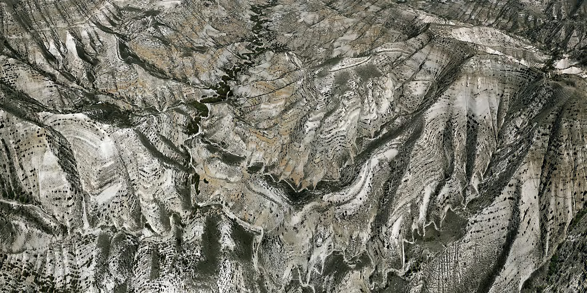
- H.Ö: Plateaus are landscapes shaped over millions of years by the combined effects of climate and the erosive force of water. They are formed through the disintegration of rock particles under changing climatic conditions, such as temperature variations and cycles of heating and cooling, and the subsequent transport and deposition of these particles by water in areas of lower slope. In a sense, plateaus are ancient mountains that have been gradually worn down by water and climate over millions of years. In Burtynsky’s photographs of plateaus, the shaping power of nature is the first thing that comes into view. While agricultural fields are visible on flatter areas, the traces of erosion, varying in intensity depending on the presence or absence of vegetation, are strikingly evident on sloped terrains. Where vegetation exists, the “footprints” of water diminish; in contrast, in barren areas, the acceleration of erosion becomes clearly visible. These images present, side by side, the power of nature and the consequences of human intervention in a highly compelling manner. At the same time, the photographs reveal the marks left by agriculture on the land: fragmentation, monoculture practices, and differences between tillage conducted perpendicular to the slope and that carried out along the slope. In Türkiye, the average size of agricultural land per producer is around 40 decares, whereas in developed countries, this figure is 5 to 10 times higher. This is, for sure, partly a result of the rugged terrain of Türkiye. However, as the population increases, land parcels get smaller, intensifying this pressure even further. This clearly shows that agriculture cannot be practiced everywhere, and the agricultural lands we have must be protected with much greater care. Another striking feature is the largely barren areas outside agricultural land. Due to excessive and irregular grazing, these areas have shifted from being protective landscapes that prevent erosion to becoming sources of erosion themselves. Today, erosion is observed in 39% of agricultural lands of Türkiye due to the lack of adequate soil conservation measures. Yet one of the most important methods to protect soil in agricultural lands is to cultivate it correctly. By placing right and wrong side by side, Burtynsky’s photographs deliver a powerful warning: if we do not bring soil together with vegetation, we leave it at the mercy of water and wind.
- F.T: Agricultural lands and forest lands represent two fundamentally different systems in terms of land use. While agricultural lands are shaped by human activity, forests are largely governed by natural processes. From a land-use classification perspective, agriculture should ideally be practiced on lands with lower slopes, whereas steep terrains are more suitable for forests or conservation. In Burtynsky’s photographs focusing on plateau agriculture, we observe a fragmented landscape in which these two land-use systems are intertwined. Within the same frame, one can see agricultural fields on flat areas alongside terraced and afforested slopes. Erosion-prone lands present serious challenges for farmers. In regions such as Burdur, both water and wind erosion pose significant threats to agricultural production. Monoculture farming is another major concern, as it complicates pest management. In this context, forests and afforested areas are vital for agriculture. Forests reduce wind speed, thereby mitigating wind erosion, and they support biodiversity by creating diverse habitats. Birds and other organisms in forested areas contribute to the natural management of agricultural pests. Terracing and afforestation efforts not only prevent erosion and protect agricultural lands but also create a more sustainable production environment for farmers. At the TEMA Foundation, this approach lies at the heart of our collaboration with local communities and farmers: protecting the integrity of the soil while safeguarding long-term agricultural productivity.
- In the Erosion project of Burtynsky, we also see images from Lake Tuzand Lake Yarışlı. How closely are erosion and water resource management linked in your work? When eroded soil is carried into these sensitive lake ecosystems, what kind of chain reactions occur? What conservation strategies are implemented to address both soil and water degradation simultaneously? Do you collaborate with other foundations and/or public agencies to address such complex challenges?
- H.Ö: The purpose of our foundation can be summed up in a simple yet profound statement by Hayrettin Karaca, our late Honorary Founding Chairperson, “If you want to live, you must preserve those who give you life.” Soil, water, and air are the fundamental elements that make life possible; climate is the environment in which this life unfolds. As the TEMA Foundation, we work to protect these inseparable natural assets together. Water is the origin of life. It exists not only in seas, lakes, and rivers, but also within, beneath, and above the soil and in the cells of all living things. When I look at Burtynsky’s photographs of wetlands, I see the circulation of water within the soil to capillaries in the human body. Water envelops the land in a similar way, enabling every particle of soil to generate life. These photographs convey a very clear message: soil and water are sources of life. Yet they also deliver a warning: we do not care about these two life-supporting elements sufficiently. Receding waters, drying and polluted lakes, water surfaces that have lost their blue… Lake Tuz and Lake Yarışlı have become symbols of ecosystems on the brink of collapse. One of the primary causes of this is incorrect agricultural practices. Growing water-demanding crops in arid areas, excessive and inefficient irrigation, depletion of aquifers, and the diversion of rivers that feed lakes all trigger a chain reaction leading to the drying of these ecosystems. Globally, between 1970 and 2024, 22% of wetlands have been lost. What has disappeared is not only wetlands themselves, but the life they support. Wetland-dependent biodiversity has declined by 85%, and 65% of the remaining areas have lost their natural character. For years, the TEMA Foundation has drawn attention to this alarming situation by stating,
“Let Türkiye Not Become a Desert.” Desertification is often misunderstood. It does not simply mean land turning into desert, but rather the degradation of land and water resources, especially in arid and semi-arid areas. The loss of wetlands is as much a part of desertification as land degradation. Fight against desertification requires sustainable land and water management. Since our establishment, we have worked to promote sustainable agricultural practices that address soil, water, and biodiversity together, and we tackle erosion control in conjunction with water-efficient and conservation-oriented irrigation policies.
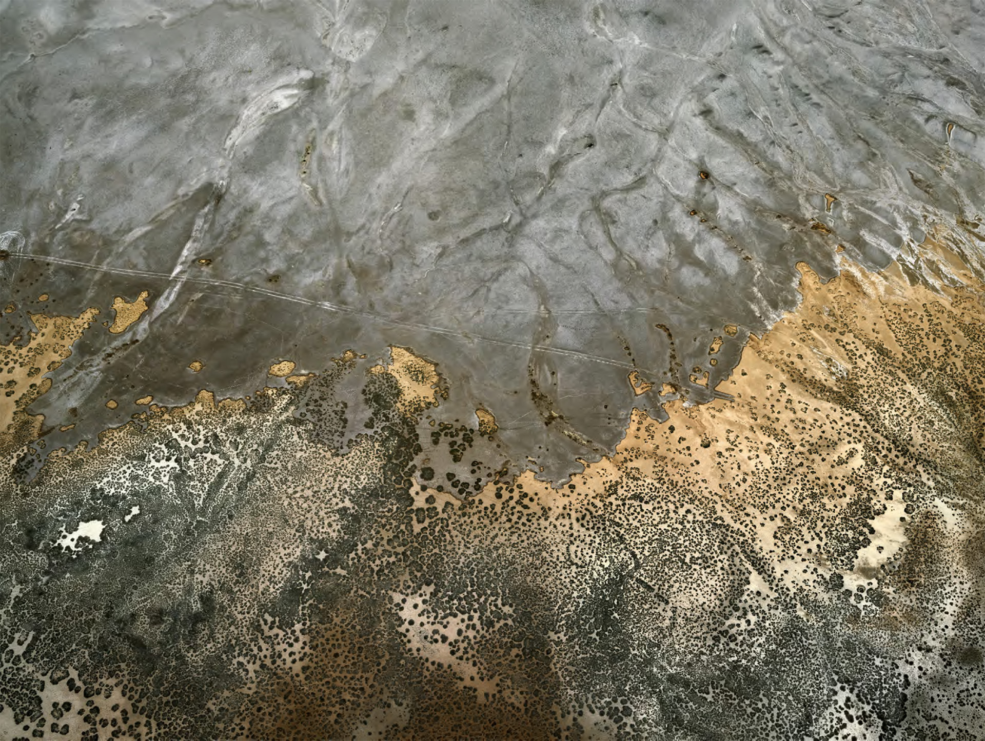
- F.T: In Burtynsky's photographs of Lake Tuz and Lake Yarışlı, we see the water surface shrinking and the lake lands that were once covered by water but have gradually become exposed over the years (Images 4 and 5). These are truly alarming scenes in terms of the impact of climate change on lakes. Soil and water are inseparable elements in nature; both are indispensable for life. When we examine the relationship between erosion and water, this interconnection becomes clearly visible. A significant portion of soil loss in Türkiye is induced by water erosion. The best way to protect soil is to retain water where it falls. This means reducing surface runoff and increasing infiltration, in other words, the absorption of water into the soil. In this way, the amount of water available for plants increases; surplus water reaches groundwater aquifers, and part of it contributes to rivers and lakes through subsurface flow, ensuring a more balanced hydrological system. Therefore, ‘soil conservation’ and ‘water production’ are essentially two sides of the same process. Today, the increasing drought caused by climate change, combined with the utilization of water resources by different sectors, has led to serious reductions in lake water levels and shrinking lake surfaces, as seen in Lake Tuz and Lake Yarışlı. When coupled with the increased evaporation losses, many of our lakes and wetlands face the risk of disappearance. As the TEMA Foundation, we draft policy reports and run projects focusing on climate change mitigation, sustainable water management, and efficient water use in response to such risks. In collaboration with the Ministry of Agriculture and Forestry and the Ministry of National Education, we have implemented the Water Brotherhood Project, aimed at raising awareness of the importance of water resources, water ecosystems, water efficiency, and water footprint among children. In all rural development projects we implement, climate adaptation, efficient water use, and improving irrigation efficiency in agriculture are among the key priorities. Within this framework, we collaborate with numerous institutions.
- Last but not least, I would like to conclude this interview with a question about TEMA Foundation's future projections by asking, “What lies ahead?” How does the TEMA Foundation envision transforming the Earth over the next 10–20 years? What are the greatest challenges lying ahead? How is your fight against erosion evolving in the face of the climate crisis?
- H.Ö: As a foundation, we emphasize that we are facing two major human-induced threats: climate change and biodiversity loss. This is not only acknowledged by civil society organizations active in the field of environmental issues, but also by the private sector. In the risk analyses by the World Economic Forum in Davos, a significant portion of the top five global risks—both in likelihood and in impact—fall under these two categories. Moreover, we are experiencing their impact not in the future, but today. Depleting water resources, increasing droughts, losses in agricultural production, extreme weather events, floods, heat-related deaths, and forced migrations… If we follow “a business as usual” approach, we are heading toward a future that is more fragile, more constrained, marked by escalating problems. For this reason, urgent steps must be taken to halt climate change and biodiversity loss. While the primary driver of the climate crisis is the use of fossil fuels, the second most critical agent exacerbating it is land degradation. The destruction of forests and grasslands, the loss of wetlands, land degradation, and pollution are also among the primary causes of biodiversity loss. Our vision for the future is a world in which this degradation is halted and sustainable living prevails. In the coming years, our goal is to contribute to a process in which carbon and ecological footprints are reduced, land degradation is halted, and restoration efforts are completed on at least 30% of degraded lands. For this, responsibility rests with both institutions and individuals alike. Economic and political decisions must prioritize life over consumption, and all segments of society must call for such transformation. We hope to live in a world where ecologically literate individuals—who understand that happiness does not come from consumption, who consume only what they need, who are aware of the burden they place on nature, and who protect the very systems that sustain life—become increasingly common.
- F.T: From the perspective of natural processes, a period of 10-20 years is quite short. Many transformations in nature cannot be observed within such a timeframe. Moreover, we are confronted with major, cumulative human-induced challenges such as climate change and biodiversity loss, which transcend regional boundaries and demand global responsibility. Therefore, expecting miraculous transformations within this timeframe would not be realistic. However, we believe that with a determined, science-based, and long-term roadmap, a sustainable future is achievable. If human activity is the root cause of today’s environmental problems, we know that solutions must also come through human action. This 10–20-year period also corresponds to the time required for a new generation to emerge. For this reason, education and awareness are among the most critical priorities. Our goal is to strengthen a society that is aware of environmental degradation, understands its impacts on life, adopts the principles of sustainable living, advocates for environmental rights, and demands accountability from decision-makers. Only through such a societal transformation can a future be possible in which soil, water, and biodiversity are protected; erosion, land degradation, and desertification are reduced; water resources are used sustainably; forests expand; and environmental pollution declines. Since its establishment, the TEMA Foundation has been working toward this transformation with the support of its volunteers and stakeholders. Through more than 500 exemplary projects, ranging from education and afforestation to rural development, climate action, biodiversity, and advocacy, it continues to foster hope by reducing and reversing damage to nature.
ABOUT THE WRITERS
Başak Sönmez Beyazyürek
Başak Sönmez Beyazyürek is an arts and culture professional whose work focuses on communications, content development, and cross-sector collaborations. She holds a BA in Social and Political Sciences from Sabancı University and an MA in Cultural Management from Universitat Internacional de Catalunya. With experience spanning museums, arts organizations, and creative agencies, she has contributed to national and international projects in brand identity, visitor experience, and strategic communication. She currently serves as Museum Manager at Borusan Contemporary, overseeing partnerships, stakeholder engagement, corporate communications, program development, and the coordination of the museum’s administrative and operational activities. She is also a member of the Advisory Board of the Faculty of Communication at Istanbul Bilgi University.
Dr. Hikmet Öztürk
Dr. Hikmet Öztürk completed his primary and secondary education in Vezirköprü district of Samsun province and graduated from the Istanbul University Faculty of Forestry in 1983. He completed his master's degree at the Institute of Science, Department of Silviculture and Afforestation of the same university between 1983 and 1985. In 2003, he received his PhD from Akdeniz University, Institute of Science, Department of Biological Sciences, and was awarded the title of "Doctor."
Dr. Öztürk's professional development has been internationally significant. In 1993, he received two months of training in Finland on forest tree breeding practices, the establishment and planning of progeny trials, as part of a program coordinated by the Finnish Forest Research Institute and the Tree Improvement Foundation. In 1996, he participated in a one-month training program at Cranfield University in England on the planning of forestry research. In 1998, he attended a three-week short-term training program at the University of Alberta in Canada on population genetics and the conservation of genetic resources.
Dr. Öztürk began his professional career as a Forest Management Engineer at the Directorate General of Forestry, Department of Forest Administration and Planning, between 1986 and 1992. In 1992, he was appointed to the Directorate of Forest Tree and Seed Improvement Research. He served in this institution in the capacity of engineer, chief engineer, and deputy director until 2010, when he retired.
Dr. Hikmet Öztürk served as the Head of the Forestry and Rural Development Department at TEMA Foundation between October 6, 2010, and August 1, 2017. He continued his duties as the Deputy General Manager of TEMA Foundation between August 1, 2017, and September 1, 2025. Since September 1, 2025, he has been working as a consultant at TEMA Foundation.
Dr. Öztürk is married and has two children.
Dr. Ferhat Taze
Dr. Ferhat Taze completed his primary and secondary education in Gölcük district of Kocaeli. He graduated from Istanbul University, Faculty of Forestry, Department of Forestry Engineering in 2004. He completed his master’s degree in Environmental and Forestry Law at the Institute of Science, Department of Forestry Engineering of the same university in 2008. He received his PhD in Environmental and Forestry Law from Istanbul University – Cerrahpaşa Graduate School in 2022.
His master's and doctoral theses are titled "The Legal Status of Protected Areas in Türkiye" and "The Place of River Basin Management Plans in the Plan Hierarchy in Türkiye and the Legal Analysis of Public Participation in Basin Management" respectively.
Dr. Ferhat Taze has been working at TEMA Foundation since 2007. Since 2017, he has been the Head of the Forestry and Rural Development Department, where he conducts research on nature conservation, forestry, rural development, and watershed management.
Dr. Taze is married and has two children.
Share on

Borusan Contemporary,
is a contemporary art, collection and education initiative of the Borusan Kocabıyık Foundation.
Personal Data Protection
Cookie Policy
© Borusan Contemporary, 2026.
is a contemporary art, collection and education initiative of the Borusan Kocabıyık Foundation.
Personal Data Protection
Cookie Policy
© Borusan Contemporary, 2026.
FOLLOW


BORUSAN CONTEMPORARY